
By Mary Kyle McCurdy | 2.5-minute read
Wildfire is a natural part of the western ecosystem, but human-caused climate change, decades of wildfire suppression, and sprawl development into the wildland-urban interface (WUI) have increased the frequency, intensity, and areas impacted by wildfires in Oregon.
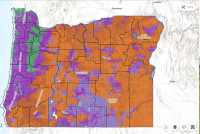
To help address this, wildfire scientists at Oregon State University (OSU), at the direction of the legislature, have developed a map characterizing the wildfire hazard for each property across the state – high, medium, or low – to help every Oregonian better prepare for future wildfires. Ahead of releasing the draft map online, the state held six open houses in areas of Oregon with the highest wildfire hazard.
Residents in these hardest-hit communities had the chance to learn about the map and get their questions answered about resources available to them, defensible space, home hardening, and more. More than 500 people attended and were able to ask questions one-on-one with representatives from OSU and state agencies, including Oregon Department of Forestry, Oregon State Fire Marshal, the Building Codes Division, and Division of Financial Regulation (the state’s insurance regulator) of the Department of Consumer and Business Services, the Department of Land Conservation and Development, and the Wildfire Programs Advisory Council.

Oregon’s land use program offers important tools to help keep our homes and communities more wildfire resilient, the most powerful of which is our urban growth boundaries (UGBs). Thanks to UGBs, Oregon’s compact cities and towns mean we do not have the extensive sprawl into the wildland-urban interface that our western neighbors have had, which both reduces the risk of wildfire and lessens the numbers of people, homes, and businesses exposed to wildfire.
The draft statewide wildfire hazard map is now available for the general public to view, initiating a public input period that runs through August 18.
This map is one of many steps the Oregon legislature has taken to provide Oregonians and Oregon communities the information, tools, and assistance we all need to be better wildfire-prepared and safe. As explained by OSU, the map will be used to:
- Improve the safety and well-being of communities across Oregon.
- Help Oregonians understand the wildfire hazard in their community.
- Help public agencies objectively prioritize wildfire hazard-reduction efforts.
- Implement a statewide strategy to improve wildfire resilience.
- Inform where statewide defensible-space codes and building codes may apply in high-hazard areas in the WUI.
The draft statewide wildfire hazard map is now available for the general public to view, initiating a public input period that runs through August 18. You can comment on the maps through the Oregon Department of Forestry now. The statewide wildfire hazard map will be finalized by October 1, 2024.