
Strategies to make evacuations and emergency responses safer and more effective
By Mary Kyle McCurdy | 5-minute read
Check out our weekly Wildfire Wednesday newsletter (sign up here) and website updates, and check out our biweekly #WildfireWednesday content on Facebook, Instagram, and LinkedIn. We also would love to hear and amplify your stories; please email us with your ideas!
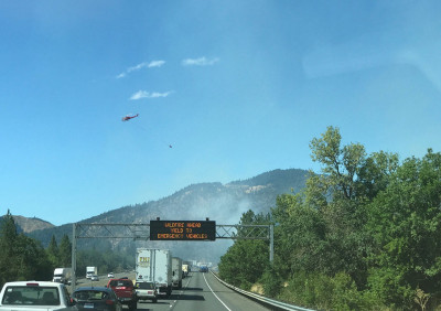
During too many fires across the western United States, including in Oregon, we have seen life-threatening traffic snarls. This can happen because incoming emergency vehicles and people fleeing wildfires are using the same routes, or because there is only one available route away from a wildfire that is quickly clogged with people escaping in vehicles and on foot. Oregon’s land use planning program provides the tools to address this.
Oregon’s 19 statewide land use planning goals include Goal 7, on natural hazard planning, and Goal 12, on transportation. Goal 7 requires cities and counties to address natural hazards in their land use plans, including a specific call for wildfire planning. Goal 12 requires cities, counties, and the state to create transportation system plans that ensure that all residents have safe and accessible options to get to school, jobs, stores, and services. Goal 12 covers transit, roads, pedestrian, rail, bicycle, water, and air transportation.
Oregon has not integrated transportation planning and natural hazards planning—yet. And that means Oregon does not currently require wildfire-informed transportation planning. It’s time to change that.
Smart transportation planning can keep Oregonians safer from wildfire risk in two ways: Through planning and communicating routes for evacuation and emergency response, and through wildfire-smart planning of subdivisions and neighborhoods.
When the legislature passed Oregon's comprehensive wildfire bill, Senate Bill 762, in 2021, it directed the state’s land use agency, the Department of Land Conservation and Development (DLCD) to write a report identifying any updates to local plans needed to minimize wildfire risk. DLCD did that and submitted to the legislature its Wildfire Adapted Communities Recommendations Report.
This report includes six common-sense recommendations to integrate the land use planning program's tools with the state’s efforts to reduce wildfire risk and prepare communities. However, the legislature has yet to fund any of these recommendations.
Two recommendations directly address integrating Goals 7 and 12 through wildfire-informed transportation planning. We believe it is time for the legislature to fund DLCD and local governments to carry these out:
- Recommendation 2: Cities and counties assess and improve transportation networks for safe evacuation and firefighting response.
- Recommendation 3: Cities and counties review and amend local land use codes for new development to ensure safe evacuation and efficient firefighting response.
In today’s article, we are going to address planning for Recommendation 2: Evacuation and Response Routes. Next week we will address Recommendation 3: Wildfire-Smart from the Start Development.
A critical component of community planning for wildfires, and for any natural hazard, is to ensure there are appropriate, safe, and well-publicized routes, both for people to evacuate and for emergency response personnel to get where they need to. In addition, plans should address moving a community’s most vulnerable people, such as those in hospitals and assisted living facilities, and those living in more remote areas.
The challenges of incoming emergency vehicles and people evacuating from a wildfire—all using the same routes—are exacerbated if the area threatened by wildfire is also a tourist designation. That has the potential to put even more people, without knowledge of the area, on the roads.
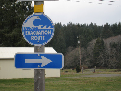
Of course, critical to the success of planning evacuation and emergency response routes is making sure they are well-publicized before and during a wildfire. Oregonians are familiar with the tsunami evacuation signs and maps along the coast. While the path wildfires can take is not as predictable as water flows, we can learn from this example and build on it.
The possibility of needing to evacuate is a serious and dangerous reality for many regions of the state, but it is definitely solvable with a bit of investment from the state to boost local capacity. Planners, elected officials, local leaders, and community groups need to come together across city, county, and regional levels to develop evacuation and response routes; integrate them into local transportation and natural hazards plans; and widely publicize them through multiple modes and in all relevant languages. This is critical to have in place before a wildfire happens.
As described in DLCD’s Wildfire Adapted Communities Recommendations Report, and endorsed by the US Fire Administration, some basic elements of a wildfire evacuation and response transportation plan should include:
- Designating evacuation routes—multiple ones if possible—and identifying improvements and ongoing maintenance needed to keep the routes accessible.
- Designating temporary safe zones for assembly.
- Providing and maintaining visible, durable signage for evacuation zones and temporary safe zones, in multiple languages, with high-quality translation.
- If there is a gated exit route, making sure everyone knows how to open the gate.
- Establishing a secondary exit/access route if an existing neighborhood or development has only a single access point.
- Incorporating transit and school bus services into evacuation plans.
- Integrating these routes and other elements into every jurisdiction's Transportation System Plan and natural hazards plan.
In addition to its own wildfire experiences, Oregon can look to and learn from places like Paradise, California, where the Camp Fire burned into the town for over two weeks, destroying 85% of its buildings and killing 85 people. It is how Paradise is rebuilding that can inform what many Oregon communities should be doing now: creating, maintaining, strengthening, and signing multiple evacuation and response routes.
Oregon has what many other places lack: A land use planning system that provides exactly the structure needed for multiple levels of government, working with residents, to plan for safe and accessible evacuation and response routes before they might be needed. All that is needed now is a small amount of funding, relative to the payback, for local governments to be able to engage in these community conversations and establish these routes.
Next Wildfire Wednesday: Integrating land use planning and wildfire preparedness: Transportation, part 2.
See all Wildfire Wednesday content here