
Disinformation makes Oregon less wildfire resilient
By Mary Kyle McCurdy | 3.5-minute read
Check out our weekly Wildfire Wednesday newsletter (sign up here) and website updates, and check out our biweekly #WildfireWednesday content on Facebook, Instagram, and LinkedIn. We also would love to hear and amplify your stories; please email us with your ideas!
The only way that Oregonians—and their families, homes, businesses, natural areas, crops, livestock, and watersheds—can live safely with wildfire is to follow the science and take certain steps, both individually and as communities.
In response to the devastating 2020 Labor Day fires, the Oregon legislature established the state’s first comprehensive wildfire mitigation program in 2021, creating a structure across 11 state agencies to coordinate efforts, increase critical investments in wildfire mitigation and safety, and establish much-needed ongoing programs in community wildfire resilience.
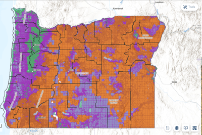
Senate Bill 762, as modified by subsequent legislation, also required the state to develop a wildfire hazard map, indicating the regions of the state where the wildfire hazard to people and communities was high, medium, or low.
In areas where high hazard and the wildland-urban interface (WUI) overlapped, property owners were to establish “defensible space” (which is defined in SB 762 as “a natural or human-made area in which material capable of supporting the spread of fire has been treated, cleared, or modified to slow the rate and intensity of advancing wildfire and allow space for fire suppression operations to continue”) around their homes and new single dwellings had to be built following wildfire resilient building codes.
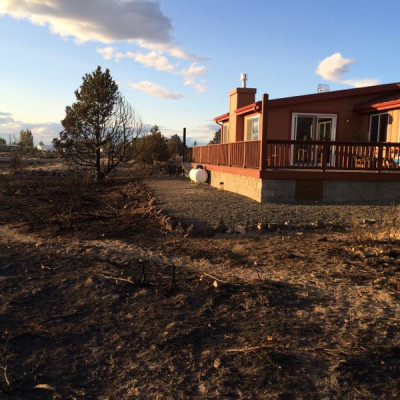
Why? The major way in which wildfires spread that harms homes and communities is through fire embers being blown up to two miles away from the wildfire’s origin, thereby setting alight roofs, decks and outdoor furniture, fencing, and other flammable materials on and near homes, and creeping inside homes through eaves and other openings.
Building wildfire smart from the start makes sense—for homeowners, communities, firefighters, and the state. Studies have established that building new homes according to the International Wildland-Urban Interface Code costs about the same as using traditional materials and methods (2–11% more expensive), and greatly reduces the chance of that home catching on fire from spreading embers. This research is led by Headwaters Economics, an independent nonprofit research group focused on community development and land management.
“If we’re going to be building homes, let’s require them to be built in a way that keeps them from burning down,” said Doug Green, a former Bend firefighter and land use planner who runs wildfire programs for Headwaters.
Unfortunately, community safety, science, and cost-effective wildfire protection gave way to fear-mongering and a disinformation campaign. Private property rights groups and others told Oregonians that the state’s wildfire map could cause some homeowners’ insurance rates to increase or to not be renewed, or that draconian regulations would be imposed on homeowners. Neither of these was a responsible allegation.
Insurance companies have long had their own proprietary data and maps on many conditions, including risks of wildfire, hail storms, flooding, tornadoes, and hurricanes. Does anyone seriously think that the primary reason the insurance industry knows which areas in Oregon are more prone to wildfire is because of the state's map? If that was the case, insurance companies would not be in business long.
Nonetheless, the Oregon legislature repealed the wildfire hazard map in 2025.
Of course, the best way to actually maintain insurance coverage, and at reasonable rates, is to reduce wildfire risk to one’s property and community—the very thing that Oregon’s wildfire map was designed to help achieve. And while Oregon repealed its wildfire map, other states are adopting maps, many with accompanying regulations to increase wildfire safety. Colorado, California, Arizona, Texas, New Mexico, Utah, and Texas maintain official wildfire hazard maps that assess risk at a detailed level. Washington State is also developing a wildfire hazard map.
We can’t afford to ignore these realities—as, frankly, many did when they responded to the fear-mongering campaign that successfully demanded that the legislature repeal Oregon’s wildfire hazard map. We all pay when wildfires happen—through our tax dollars, our health, our insurance rates, our utility bills, and more. A better, safer, and sustainable future is possible, but it calls for joining hands and working together.
Next Wildfire Wednesday: Community actions and policy changes to help Oregonians live with wildfire, part 1.
See all Wildfire Wednesday content here